Mountain Climbing and Hiking in Uganda
The top places for mountain climbing and hiking in Uganda
Rwenzori Mountains
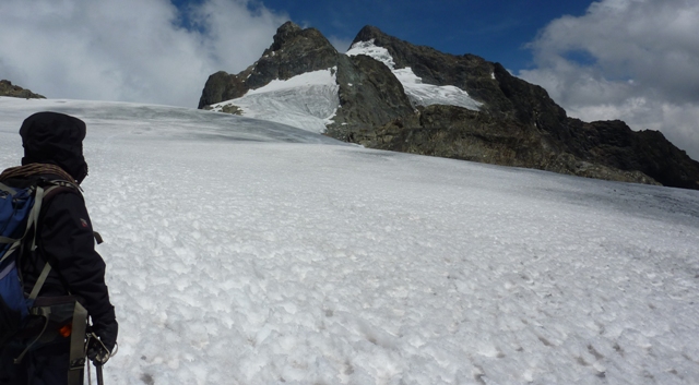
The Rwenzori mountains are found along the border of Uganda and the Democratic Republic of Congo, covering a length of 120km and width of 65km. They have Africa’s third highest mountain, Mt. Stanley that stands at 5109m, and are also one of the only three on the continent with permanently snow capped peaks. In Uganda they make up the Rwenzori Mountains National Park, the prime destination for mountaineering in Uganda.
The Rwenzoris support an array of rare and endemic wildlife, stunning glaciers, beautiful waterfalls, rivers and lakes. Basing on the stunning beauty and block type formation, the Rwenzori were ranked the best in Africa and ninth in the world for mountain climbing and hiking adventures . There are a number of trails travelers can take to for exciting treks into the mountain. The longest trail, called the Central Circuit, is 8 days (7 nights) and includes the chance to climb to the highest peak of Margherita for those who can manage. There other shorter trails that offer easier treks such as the 3 day Mahoma loop, 1 day Chimpanzee trail and 1 day Kilembe trail.
Mountain Elgon
Mountain Elgon, 4321m, lies in eastern Uganda on the border with Kenya, its highest peak Wagagai situated on the Ugandan side. It was one time, thousands of years ago, Africa’s highest mountain but was gradually eroded at the peak reducing it to the current height of 4321m – 8th in Africa, 4th in East Africa. The mountain also possesses the the largest caldera in the world measuring 50km by 80km. Climbing Mt. Elgon is not one of simply targeting to reach the summit, it is more about discovering the fascinating wildlife along the slopes. The varied vegetation zones harbor plenty of wildlife that you may encounter during the trek. There are also fascinating features such as caves, water pools, falls, and wonderful scenery. There are two major trails that lead to the peaks, taking 4 to 5 days. One is called the Sasa trail (Budadiri trail head), accessible from Mbale, is the more direct to the peaks and goes through the largest area of bamboo forest. The second trail is called Piswa and is known to be a more gentle hike than the Sasa.
The Sipi Falls
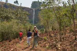 The Sipi Falls is a set of three waterfalls (85m, 75m and 100m) situated along the foothills of Mountain Elgon. They arguably are the most beautiful waterfalls in Uganda and have become one of the iconic attractions of the eastern region. Sipi, easily accessible from Kampala, has become very popular for day hikes. The trek to visit all the three waterfalls covers a trail of about 7km and on average takes up to 3 hours to complete.
Read more about hiking Sipi Falls
Top of the Murchison Falls Hike
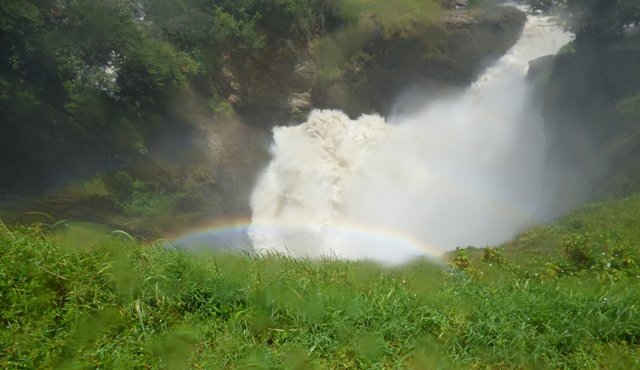
This is another of the famous waterfall hikes in Uganda. The hike from the bottom to the top of the most powerful waterfall in the world – Murchison Falls – is not done as an independent hiking tour but rather as part of a wildlife safari trip to Murchison Falls National Park – Uganda’s biggest and most popular park. The Murchison Falls is by far the biggest highlight of the safari in the park. The top of Murchison Falls hike is one of the shortest hikes you can do in Uganda (only 45 minutes) but one of the most thrilling as you will hike along the explosive falls created when the entire River Nile squeezes through a small gap of about 7 meters between rocks.
Read more about the hike to the top of the Murchison Falls
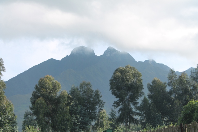
Virunga Mountains (Volcanoes)
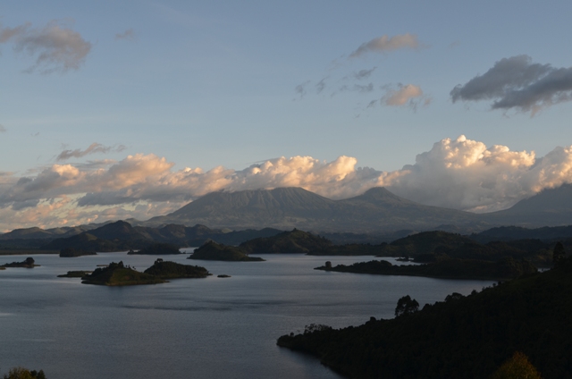 Uganda shares 3 of the main 8 volcanoes of the magnificent Virunga Mountains which straddle along the borders of Uganda, Rwanda and the Democratic Republic of Congo. The 3 are located in southwestern Uganda along the border with Rwanda and the Democratic Republic of Congo. The volcanoes offer excellent day hikes filled with some of the best views in Africa. The Virungas harbor lots of unique and rare wildlife which you have chance of encountering such as the Mountain Gorillas, Golden Monkeys, endemic birds and mountain vegetation.
Muhabura (4127m):
It starts the chain of the Virungas, situated on the Rwanda – Uganda border. It is longer hike to the summit taking about 5 hours which makes it tough, and coming down takes roughly the same. It has a small crater lake at the summit which can easily circumnavigated to get access to views across the Virunga ranges.
Mgahinga (3474m)
This is a much smaller mountain of the three, situated between Muhavura and Sabinyo, but closer to former. It is a short and easier hike. It is bigger crater lake at the summit which isn’t so easy to circumnavigate to gain better views.
Sabinyo (3645m)
 This is situated on the common border of the three countries Uganda, Rwanda and Democratic Republic of Congo. It is the most challenging of the three because of a more rugged terrain with many craters, but most fun and has the best views of the Virungas stretching across all the three countries. It has three peaks which look like three spaced teeth, hence the local name Sabinyo which translates “Old Man’s Teeth”.
Read more about the Mount Sabinyo hike and tour
Hiking and mount climbing tours in Uganda
5 days gorilla trekking and volcano hiking trip
3 days Sabyinyo volcano hiking tour
2 days Sipi falls hike and Jinja tour
10 Days Mount Rwenzori climbing tour
21 Days Rwenzori Mountain Climbing adventure and Uganda Wildlife tour
Share This!